21 June 2020

(Socially Distant) ARDF in B30


This is version 3.0. Thursday 2nd July

Date: Saturday 4th July 2020

Location: Bournville, Birmingham B30.  

DO  NOT PARK NEAR MY HOUSE

Pick one of these at random...

B30 1XD  52.432716,-1.944211 SP0389081639
B30 1UX  52.432031,-1.941477 SP0407681563
B30 1TS  52.433190,-1.940078 SP0417181692

You will be less than 200m from the start location

Format: This will be a low key informal and socially distanced ARDF competition - parking will be dispersed, there will be no event centre point as such.  To avoid tensions with neighbours there will be no group gathering or intentional social interaction.  Be discreet.

Competitors will self start, self time and will WhatsApp (or email or SMS) time and Transmitter Codes to the organiser upon completion.

Contact the organiser using WhatsApp or SMS. The former is preferred.

Number is 0~7~9~3~4~7~8~9~6~8~9 (WhatsApp, SMS, Voice)

Backup number is 0~7~4~4~7~6~9~8~8~2~6 (SMS or Voice).  On the event day only.
Email: BVARDF@ddwilliams.net

Transmitting Times : From 11:00am to 15:00 (80m), 15:30 (2m). I am aiming to have all the transmitters in positon for 10:30, so you may be able to start before 11:00.  Check in with me over WhatsApp at 10:30.   80m course it to be done first.

Courses:

6 Tx 80m sprint style ARDF - optimum route ~2km. No minimum distances between Tx, Start, Finish.  

Each transmitter will sound for 20s as part of a two minute cycle.  Cycle starts with Tx1 on even minutes.  

These transmitters only pull 100mW from the battery and have 2m unmatched/untuned antennas.  I have tested and my (rather good) Czech Rx can hear these at 300m with gain set to 6 (out of 7).  I can hear them clearly at 200m with my not so good American made Rx at maximum gain.  Distances between transmitters are up to 300m so you may not hear them all from the starting location.  

Tip: If the Tx is very quiet, too quiet to use the "null" - press the sense button and wave your Rx around to get a rough direction.  

There is considerable radio noise from broadband cables running in ducts under the pavement.  Only a problem if you are within a few metres of where cables t-off from the main run.

Tx batteries should be good for the duration of the event.

Near each transmitter there will be strips of yellow flagging tape (example at the start)  - on which will be written a letter code.  Write down or remember this code.

The competion zone and start location (purple triangle) are shown on this map... 


The start is by the VERY BIG oak tree. 

WC and the small yellow dot  show a secluded spot if you need a pre-race wee.

You can start with any transmitter and take them in any order but you MUST finish with Number 6.

There is no time limit.

6 + B Tx 2m Classic style ARDF - direct line shortest distance ~5km.  No minimum distances between Tx, Start, Finish.  

Tx1-Tx6 will each sound for 50 seconds, in sequence over a 5 minute period and then repeat. 

The beacon will transmit continuously and will be within 400m of the start. It is not shown on the map.

Near each transmitter there will be strips of pink flagging tape (example at the start)  - on which will be written a letter code.  Write down or remember this code.

The competion zone and start location are shown on this map... 


Frequencies: I don't know - you will be permitted to "tune in" before starting but please don't take any "pre-bearings".


Map: This will be Open Orienteering Map based:


Here is the 80m map: https://drive.google.com/file/d/1jYUuYjbD7kMJuF0JPSMRckE3Wt7cDXEd/view?usp=sharing

Here is the 2m map: https://drive.google.com/file/d/12sFa3ouvldtjdwPGPYcH_8V_9L8DK12I/view?usp=sharing

These are PDF format, A4 size.  Download and print these maps.

You are welcome to use any alternative map - A-Z, OS, Google, Open Streep Map, Open Cycle Map.

There are a number of orienteering overlays for Open Street Map (google Open orienteering Map and play around with the settings).

Guidance is: 
  • Public areas only.
  • Please stick to roads, paths, tracks, open parkland and wooded areas. 
  • Do not climb fences.  
  • Do not enter what is clearly private residential property and gardens. 
  • Do not enter school grounds.  
  • There are areas of University property which can be freely accessed by vehicular traffic - these will be in-bounds.  
  • The Cadbury recreation grounds may be passed though but please don't run across the pitches or bowling greens. 
  • You can run along the access roads (west and north) to Cadbury World and through the car park. 
  • Respect and defer to other runners, pedestrians, cyclists and VEHICLES.
Entry Fee: no charge

Facilities:  None - except for Females by arrangement or Male Emergency.  There is a nearby, secluded copse for discreet pre-race #1's. This is indicated by WC on the 80m competition zone image.

Loan Receivers:  A limited number can be made available - but these will need to pre-booked with the organiser at least 24 hours in advance so that they can be charged, sanitised and bagged.

Competition Arrangements: 
  • If it is dry then standard road trainers will do.  If it has been, or is currently, raining - trail shoes might be better.  You will pass through woodland areas - it is not necessary to pass through brambles or nettles but you may decide to do this.  I recommend wearing full lower limb covering.
  • No time limits.
  • Pre-listening - only that necessary to tune in to the transmitter frequency.
  • Starting - Self timed - 80m on the start of even minutes, 2m on 5/10/15 etc. minutes.  Take a photo as you start (I will be using the EXIF data for location and time)
  • Transmitter locations will be marked with a "flagging" tape with a code letter
  • Finish - Self timed.  Take a photo of your watch showing elapsed time.  80m finish is at Tx6.  2m at the beacon.
  • Results - take a photo of your control visiting record or type in the codes
  • If you do not own a smartphone or other means of taking a "transmissible electrical daguerreotype" or of sending a "graphical wireless telegram" then we will come to an alternative arrangement.


Safety
  • You are responsible for your own safety.
  • I will not be checking people onto and out-of the course.  Please make your own arrangements with family or friends.  There are some very quiet areas where your would not be found if injured or unconscious.
  • Nearest A and E is the QE, B15 2WB ten minutes by car.
  • Bournville is a leafy suburb with roads, streets, parks, cut-throughs, areas of scrub and woodland, lots of deep water, many cyclists, dogs and members of the public.  Expect hazards consistent with the above.
  • You will certainly cross and run along suburban roads and streets - these are currently quiet but traffic can be fast.  There are two major A roads within the competition area.  Take appropriate care when crossing.  Beware that drivers may not correctly anticipate your actions - do not put them in a position where they may decide slowing down for you is the best option - as following drivers may not realise this. 
  • Be especially careful of cyclists - you will encounter them traveling at high speed on footpaths and pavements and they will not notice, nor care, that you can't hear them approach.
  • No unaccompanied under 16s.
 -END-


07 June 2020

Socially Distant June Jaunter 2020


This year the HOC June Jaunter will be run as free starting time trial.  The course is open from 11th to 18th June


Start and finish by the information board in the Walton Hill carpark. https://goo.gl/maps/wZ57sqdWQZFydy7a6

As in previous years this is not just for HOC members - everyone is welcome to take part as long as they understand and accept that:

  • It is not a race. It is not registered with British Orienteering or any other sport body. This guidance, map PDF and maprun course are provided "as is" for you own entertainment, at no charge and with no warranty all on the understanding that you run at your own risk and indemnify the provider etc. etc. etc.
  • Part of the course is on public roads and car parks - please take care.
  • Part of the course is on multi-use tracks - please respect other users.  Tracks are uneven and several are not maintained.  They can get muddy and slippy.

If you need a copy of the map then download and print this PDF:  https://drive.google.com/file/d/1RxGCxsjP3Grc99dlG3hcl-YLTxChNQol/view?usp=sharing

Four Checkpoints.  For Anti-Clockwise:

  1. Nimmings Carpark - South end of access gate.
  2. Four Stones on the hill top.
  3. Clent Church (Round the back, by the gate just before your enter or leave the field). Run right aroud the church - do not cross the churchyard.
  4. Walton Hill Trig point.
Reverse for clockwise.

The route is free between the checkpoints but please do not cross fields or private property.

You can run as many times as you like but only your fastest time will be entered in the archive:  http://www.harlequins.org.uk/june_jaunter_records_2018.xls

In order for your time to be recorded in the results please run according to one of these options

Option 1 (Preferred) - MaprunF.

You will need a GPS Enabled Smartphone.
Two courses have been created - Clockwise and Anti-Clockwise.


You will need to install MaprunF from the appropriate App Store for your phone.
If you are not up to speed with Maprun there is lots of information on the web.
Key is to make sure that your phone is not going to pause or terminate the app/your run.
You probably don't need to worry about this but you may wish to check the settings and make sure MapRun is the forground app before you "lock" your screen.
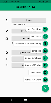
If you want to practice - press on the "three lines in the green circle" and select Quickstart Event and create and event around your local area.


You may wish to confirm "options and settings" - and make sure "Display Orienteering Map Overlay" is enabled and "No sound or vibration upon punching" is disabled.

Event settings will be taken from event file but you may wish to select Automatically Upload Results. if it is not selected already.

Set up your user details - this is how you will appear in the results.  For club - enter Harlequins Orienteering Club unless you are a guest - in which case your running or other sports club.


Before you travel - download your preferred route and the test course (if you like).  These will then be in your phone's cache which you can access without a data connection (you will see a button 'Access Local Events Offline'.)


Select Event > UK > West Midlands > Clent Hills > June Jaunter Anti-Clockwise PZPXAC
Select Event > UK > West Midlands > Clent Hills > June Jaunter Clockwise PZPXAC
Select Event > UK > West Midlands > Clent Hills > June Jaunter TEST Course PZPXAC

There are other ways of getting the event - "Events Near Me" option if you are already at Clent for example.


When you are ready to run.  Make sure you have max volume selected for notifications on your phone (I make sure ALL the sliders are at MAX) and you do not have "do not disturb" enabled.  Select the appropriate event. Make sure you are not near the start.  In the car park if you are going clockwise and in the woods if going anti-clockwise.  Select Go to Start and enter the appropriate PIN...

Anti-clockwise 1563
Clockwise      3241
Test           6032


(You may wish to test this before you leave home - but you will need to PIN again before you start 'for real')

You should now see the map and the course.
  • Wait until the GPS has a good lock - the bar at the bottom of the screen should be green and GPS: xxm where xx is less than 15.
  • Lock your phone and put it away.
  • Walk toward the start and when you hear the beeps - start your watch and start running.  If it all goes wrong - you can cancel your run and try again.
  • Visit all 4 checkpoints in the correct sequence.
  • As you approach the finish - and you hear the beeps - stop your watch.(You may wish to start and stop your watch exactly by the information sign - your choice.  If your watch time is very different from MapRunF - then send a photo of your watch face showing the time to JJ@ddwilliams.net
  • Unlock your phone and check the app - it should say that you are finished and that your time and route and splits have been uploaded.  If this has not happned - there is a manual upload option.
You can check the results and look at routes and winsplits and etc. directly through the app or at home from the MapRun website (select CLUB view and then hide the 2020 trunk/branch and you can scroll down to HOC.

GPS Notes: Nimmings Carpark and Clent Church CP are not GPS ideal locations - being sheltered by terrain and tree canopy.  The courses have been run twice in each direction and the full 8 CP registrations were recorded however some were a bit late (especially running clockwise).  It is best to keep moving slowly and not stand waiting for the beep. Some phones do a lot of "rounding track prediction" at sharp corners so it may take a while to register a CP if you have done a 90 degree change in track.  

Make sure your phone has a good view of the sky - it is best to run with the phone in a suitable holder strapped.  Waist located bum bags or similar are not ideal - though this worked for me.  As long as your recorded track is more or less correct your time will stand and a split time will be manually estimated.


Option 2 - STRAVA


Record your run and upload to STRAVA.  Make sure you edit the activity settings to RUN and RACE (otherwise STRAVA will trim the time).  Please record splits at the check points.


Send the organiser JJ@ddwilliams.net a link to your profile.  For Example I am at https://www.strava.com/athletes/26635926

If you have a gps track but not a STRAVA acount you can email your trck in .gpx format. 

Option 3 - Luddite Mode


Send the organiser (JJ@ddwilliams.net or facebook messanger or WhatsApp 0*7*9*3*4*7*8*9*6*8*9) a photo of your watch showing your run time, preferably with the start/finish location in the background.   Indicate if the run was clockwise or anti-clockwise.  A list of split times would be good.

If you have no convenient means of taking an "electrical daguerreotype" or of sending a "wireless telegram" then we will come to an arrangement.